
Just over 3 years ago, together with my daughter Nicola, I undertook a charity walk across Morecambe Bay. The walk started at Silverdale and went across the bay to Flookburgh. Today I would be closing that gap, but mindful that it was going to be a long day and long distance between Lancaster and Silverdale.

I parked my car close by to Gibraltar Farm, where you can actually buy raw fresh milk out of a machine. The area is not served well by buses, however, there is a train station some 2 miles away. So I had brought my push bike to cycle that distance to the station, lock my bike up and catch the 10:07 train to Lancaster. Being a Sunday this was the earliest train I could get and meant I did not begin walking until 10:30. I followed a footpath from the station down a quiet road towards the main rail bridge that crosses the River Lune. The bridge also carries a footpath which offers a good view back over Lancaster.
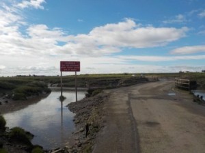

I join a cycle way that passes through a sports ground and actually runs alongside a cycle race track. Eventually the cycle way emerges onto a road which runs down to The Golden Ball Pub. The road has obviously been covered by the tide, with debris and silt littering the road. In fact I am spurred on as after Overton, I must cross a marsh via road which is flooded at high tide. I check my watch and get a move on. Via a series of roads I enter the small village of Overton. I did contemplate heading straight for the road across Lades Marsh, but I did not want to miss out on going around Bazil Point. I head towards Ferry Cottage, but am stumped by a close gate with a notice saying ‘No Public Access’. I recheck my map, surely it cannot be wrong? Then I notice a way marker indicating the footpath some 10m away. The path leads me onto the foreshore and I round Bazil Point, noting the good views across the Lune estuary to Glasson Dock. I head back towards Overton along the shore and eventually arrive at the road across the Lades Marsh. I can see that the tide is coming in ……fast. I meet another walker coming the opposite way. we have a brief chat, he advises to get my skates on. I can see the hamlet of Sunderland some 400m away. I make safe ground with literally seconds to spare!! I stop, put my bag down and turn around. The road is virtually covered by water! Absolutely amazing the speed that the tide comes in. I have a quick-lunch break, watching the tide devour the road that I had just walked across.


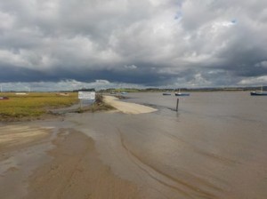
I set off along a lane walking west to this small peninsular shoreline. I make a short detour to visit Sambo’s grave. This is a grave of a site of a dark-skinned cabin boy or slave, Sambo, who fell ill shortly after arriving at Sunderland. With no further concerns re: the tide I head north, passing Potts Corner, which has a public road coming down to the shore, where a number of cars are parked. I head on past these and straight towards the building that has dominated my views for the last couple of trips – Heysham Nuclear Power Station. I know I cannot walk around the power station so will turn right inland. However, there is a large caravan park in the way. I know there is waste ground sandwiched between the caravan park and the power station, but the high tide has meant I cannot continue along the shore. I enter the caravan park and walk around the periphery until I come to a hole in the fence which takes me down a footpath. I find a hole in the fence that leads across old MOD ground but parallel to the caravan park. However, my progress is brought to a short end when a large and high gate blocks my progress. I am forced further north until I break through some trees onto a golf course. Fortunately the golf course is quite quiet. I cut across the course and through some trees to emerge on the public road that leads towards Heysham. In retrospect I should have stayed in the caravan park and just walked to the exit.

I walk down past the ferry buildings and enclosure, before turning right and following road that takes me alongside Half Moon Bay and becomes a coast path. The path leads up to St Patrick’s Chapel, which is in ruins. The site offers fantastic view right across Morecambe Bay. I walk through a few narrow streets and find a little cabin selling coffee and tea and cake. I buy a mug of coffee and a large slice of carrot cake. After 20 minutes I get on my way. I am on now one large promenade which will carry me along for the next 5 miles.
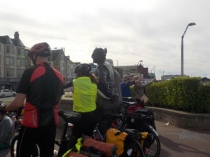
I enter Morecambe, which is buzzing with many people taking the late summer sunshine. There is a large Vintage Fair going on and I pass many ladies beautifully dressed in period clothing. There is a classic car fair as well as a group performing. I like Morecambe and I draw a comparison with a Blackpool, which is far more tacky, in your face and loud. Morecambe has taken its role as a seaside destination more in keeping traditional values. everybody seems to be having a nice time. I try to get a close-up of the Eric Morecambe statue, but is surrounded by a large group of cyclists who with their bikes are getting their photos taken. I take a photo of the statue surrounded by the cyclists and move on. The crowds thin as I continue north towards Hest Bank where I move onto the shore and also where the main West Coast line comes within a stones throw of the Morecambe Bay.
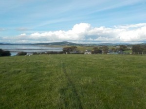
I am now back on the Lancashire Coastal Path, as I continue along the shoreline towards Bolton Le Sands. I do enter Bolton le Sands or Carnforth but pass to the west and north, where I cross the River Keer by means of a wooden bridge. The afternoon seems to have disappeared as I approach the outskirts of Warton, which the LCP enters briefly before turning up hill towards Warton Crag, part of which is the result of an old quarry. I continue along a quiet B road for a few miles, before crossing under the railway line and some fields. I arrive just east of Jenny Browns Point and follow the road up to Gibraltar Farm. It’s now 7:30 in the evening and it has been a very long day, 27 miles is one of the longest distances I have ever walked in a single outing. My legs are tired but I am happy. I drive the few miles to pick my bicycle up at Silverdale train station. The walk has taken a tough 8.5 hours.
Distance today = 27 miles
Total distance = 2139 miles

Did you do this yesterday, Alan? I’m in Lancaster at the moment! Walked from Knott End to Cockerham- I don’t do your incredible mileage 😄
LikeLike
Hi Ruth, yes. The date of all my published walks are the dates I actually do them. I was aware that you were walking around Blackpool yesterday and I could see Cockerham and Knott from across the Lune. I now leap-frog onto Flookburgh because of my Cross-Bay walk. This weekend I will probably move onto or near Barrow. Have’t decided what i’m going to do about the Isle of Walney yet.
Enjoy the section from Cockerham to Lancaster. Its quite easy going. Cheers Alan
LikeLike