
Its getting more difficult to find a ‘weather-window’ to allow me not only to have a reasonably nice walk (weatherwise) but also to get a good a mileage in. So as the first real storm of Winter (Storm Angus) batters the south coast of England, I head for the more quieter coast of West Cumbria to continue my walk.
I arrive in the small village of Allonby early morning after a severe frost. It’s about -3 deg and it’s really cold. There is also a stiff breeze blowing from the north, making it feel like -10!
To get to my start point in Whitehaven I must first get the 14min bus journey using the #60 to Maryport, then its a 30min train ride to Whitehaven. By the time the bus arrives my feet and toes are freezing.
I arrive in Whitehaven and my feet have just about thawed out. I pop into the local Tesco, which is adjacent to the station for a sandwich and biscuits. Today the whole route follows the newly opened England Coast Path. I hope I will not need to consult my maps too frequently. I must say however, the route depicted on my recently printed off OS map differs in many places to the actual signage on the ground; which seems to follow predominantly, NCN cycleway #72. I soon end up following the route shown on the map, which clings well to the coast.

I head north along the old tramway between Parton and Whitehaven. I am going at quite a pace because I am walking directly into a stiff freezing breeze coming down from the north. I am rewarded with fantastic views across the Solway to the snow-clad hills of Dumfries and Galloway, in particular Criffle, which dominates the view north. I see little of the Cumbrian Fells, which are hidden for most of the walk, although even they have a fair dumping of snow on them. I am walking alongside the railway, which I will continue to do so for most of today’s walk.


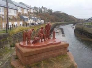
I reach the small village of Parton and pass under the railway, something I will do many times as the path continuously criss-crosses the line. I climb up above Parton onto Lowca Fell. I get an even better view now across the Solway and the Mull of Galloway now comes into view. The path then skirts around the small wind farm at Lowca before dropping slowly down a green lane into Harrington. I pass under the railway and walk around the harbour, which at low tide looks empty. I continue alongside the railway to the outskirts of Workington. The path has diverted slightly inland to bypass a huge derelict tract of land once taken by some large industrial works. Part of this site has been landscaped and I climb up onto a small hill, once slag heaps, overlooking Workington. The grey overcast skies do not make the place look any better. On this hill I pass, surprisingly a large crucifix, made out of wood and with a metallic Jesus Christ figure. It looks ok and I later find out it was built and erected by a local man whose wife had recently died. He applied for retrospective planning permission in 2015, which was granted. The effigy, gives the hill a very Calvaresque appearance.

I drop down to the banks of the River Derwent and continue to the first bridging point. I pass around the Rugby and football grounds and stand awhile on the rebuilt (2012) Northside Bridge which was swept away in the 2009 floods, which also claimed the life of PC Bill Barker, who was on duty on the bridge at the time. A plaque to Bill is set in on the bridge walkway. I had visited this bridge of a few occasions (while watching my local team play Workington) previously and I remember visiting not long after the floods, when I could see remnants and debris of the previous bridge below in the Derwent.
I move on and pass behind an industrial area and across a Traveller encampment alongside the road. The whole area, is covered in litter, fly-tipping and dogs running free. I move on and pass under the railway to gain the shore.
I next come across a local dog walker out exercising his 5 Lakeland terrier pups, they are a bundle of joy, full of energy, running here and there and very affectionate. We talk awhile, until I realise that time is pressing and continue onto Flimby. I also realise I have again followed the signs pointing me back onto the road, when I could have easily stayed on the shore.

I enter Maryport, as the rain fore-runner of Storm Angus begins to arrive. Its getting quite dark now and still only 13:30. I walk around harbour at Maryport, perhaps not giving it my full attention. I join the promenade which runs for over a mile north. I also say goodbye to the railway which skirts north-east inland towards Carlisle. Where the promenade ends at Maryport Golf Club, the signs point inland. I opt to get onto the beach and for the next 3 miles stay on the sand all the way into Allonby. The rain begins in earnest as I arrive back at my car. It is also quite dark, even though sunset is not for another hour yet. The drive home down the M6 is not very nice as the north feels the full force of the storm.
Distance today = 20.5 miles
Total distance = 2445 miles

Glad to see you managed to get some walking done, and outpaced the storm! Isn’t it funny how official coast paths often don’t follow the coast? A little bit disappointing too, since this is the new stretch of the England Coast Path 😦
I see the forecast for Cumbria tomorrow is excellent, sadly I’m in London!
LikeLike
Hi Ruth, What is annoying and confusing is that there are a number of small maps with words like “this is the route of the ECP but the route on the ground is not yet established” or something of the sort. I ended up ignoring them. The only use of the signage is when you are in built-up areas and can get directed around Urban “clutter”.
Still, it should be only two more walking trips for your self now before you catch sight of Scotland (weather permitting)! Remember, locate St Bees Head then just to the left of it you should see Cairnsmore of Fleet.
LikeLiked by 1 person